
The town of Baler is recognized as one of the premier surfing destinations in the Philippines. Strong swells from the Pacific and wide swaths of sandy beach front contribute to the popularity of the sport in this unassuming town of Aurora province. But for those of us who aren’t into surfing, no need to be dismayed. Baler offers so many other attractions you won’t regret making a trip to this coastal municipality.
Sabang Beach

Surfing is what initially made Baler famous and the most popular stretch of beach front for surfers has to be Sabang Beach, a grey-sand beach located close to the town center. This beach is largely devoid of rocks, making it safe even for beginners. Waves are largest from November to February, although just large enough for novice surfers. Advanced surfers prefer Cemento Beach and Cobra Reef to the east of Sabang where the waves are much larger. For us? It’s simply enjoying the sight of surfers strutting their stuff or enjoying the flaming colors of sunrise and sunset.

Sabang Beach is where most of the resorts in Baler may be found. It’s also home to a multitude of restaurants, cafes, watering holes and surf shops. An elevated bay walk that runs from Costa Pacifica to just past the Aliya Surf Camp Resort interconnects these establishments and makes for a great hangout after an afternoon of fun.

But Sabang Beach is merely an introduction to the many scenic spots in and around Baler.
A short distance past the eastern extremities of Sabang Beach is Ermita Hill where a white cross on its summit marks the highest point of Baler. During our visit here we climbed the 275 steps to the top only to realize that huge trees block any panorama of the town and Baler Bay. (We could at least claim we scaled the highest point in Baler.) To our chagrin, we realized one need not climb that high; a view deck on the parking lot of the hill already offers a good view of Baler town and Baler Bay.

The Tromba Marina sculpture at the base of Ermita Hill is a tribute to the survivors of the December 27, 1735 tsunami that wiped out the entire town (tromba marina is Spanish for tsunami). The sculpture depicts the few family members who were able to swim through the raging waters and climb Ermita Hill to safety – the only survivors of this tragic incident.
Diguisit and Nearby Beaches
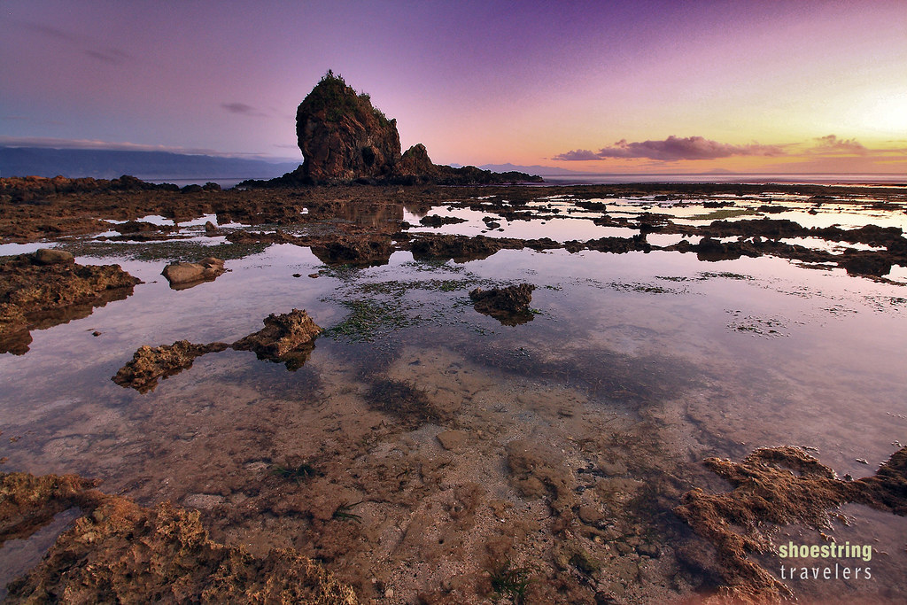
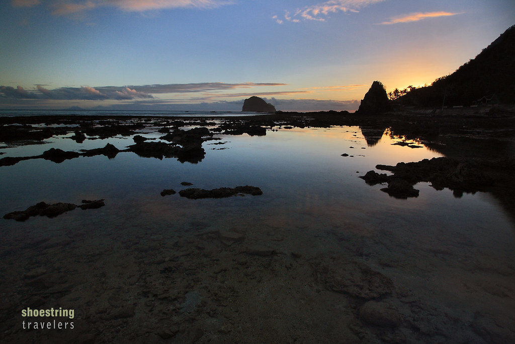
Outside Baler town proper on the coastal road that runs to Dicasalarin Cove is Diguisit Beach, a favorite subject for sunrise photos. In contrast to Sabang Beach, Diguisit has creamy white coarse sand. Its main attraction, however, is its stunning rock formations – known as the Lukso-Lukso Islets – which makes it an excellent location for capturing sunrise shots.

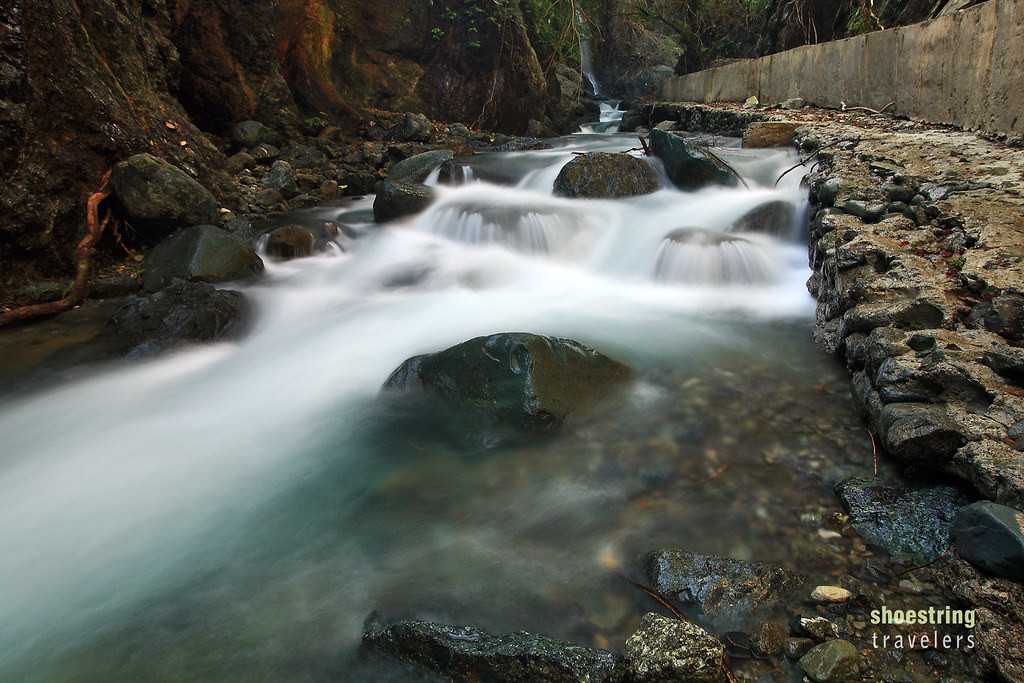
Further east are even more massive rock formations known as the Aniao Islets, while about 2 kilometers west along the same coastal road are more rock outcrops – the Dimadimalangat rock formations just off the beach Adding a little variety to the rugged topography of this part of Baler is Diguisit Falls, a multi-tiered cascade tucked into a forested area just off the main highway and less than 700 meters to the west of Diguisit Beach.
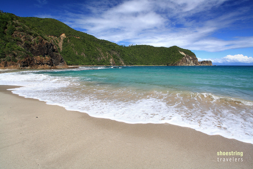
Dicasalarin Cove
The coastal road that runs east from Baler town proper ends at gorgeous Dicasalarin Cove, a piece of real estate privately owned by the Angaras (a political clan in the country). The panoramic views of the cove including the azure waters of Dicasalarin Bay are stunning and help make Dicasalarin Cove the most scenic spot in Baler in our opinion.
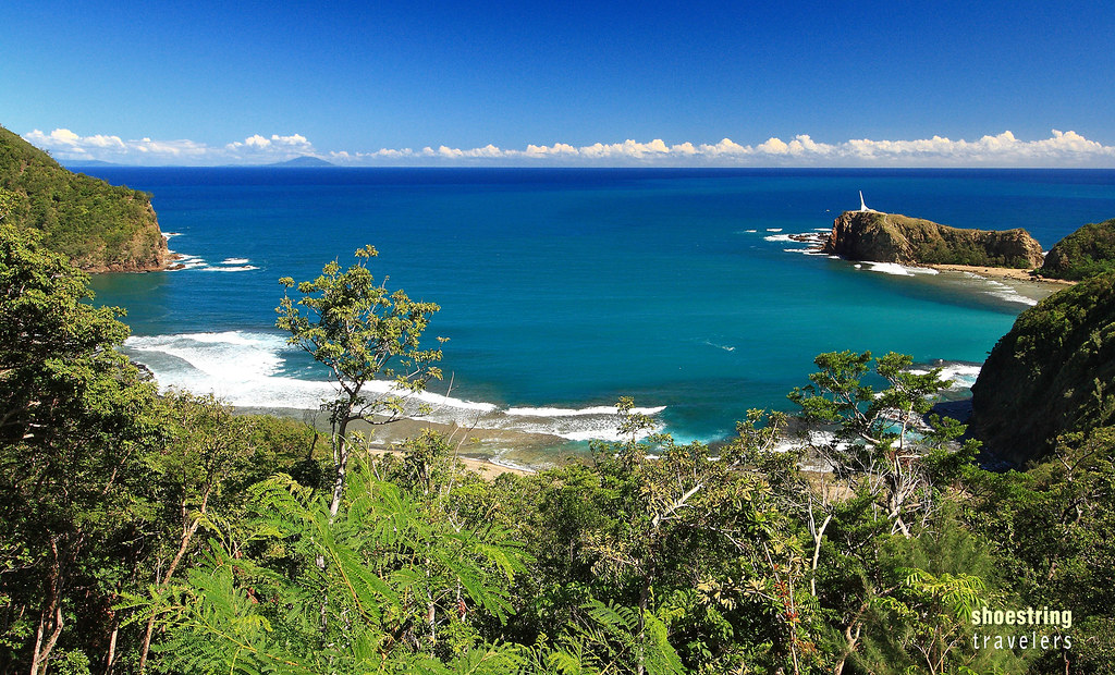
Panoramic views of the cove and white sand beach are possible from the road going up the hill and down into Dicasalarin. The road leading to the cove is so narrow vehicles can only use it one at a time; we had to ask permission from the people controlling traffic to give us a little time to stop the car and take photos of Dicasalarin Cove from the road. Another good vantage point is the Baler Lighthouse located on a hill at the eastern extremity of the cove just adjacent to Dicasalarin Point.

Unlike much of the Baler coastline the sand at Dicasalarin is off-white. Turquoise waters flanked by rocky promontories complete the magnificent scenery. Tour guides have mentioned the abundance of corals and sea life a short distance from shore but snorkeling in the strong current was just too dangerous when we visited here on a December day.
We’ve heard about beautiful Dibut Bay located just south of Dicasalarin Cove with its short stretches of white sandy beaches, scenic rock formations, rugged cliffs and remarkable marine life. Visiting the place, however, was too risky during the amihan or northeast monsoon months of December to February due to the strong waves. Dibut Bay is part of San Luis town.
Ditumabo Falls
Locally known as the Mother Falls, the Ditumabo Falls is actually located outside Baler, in the nearby town of San Luis. The jump-off point for trekking to the falls is about 15 kilometers from Baler town proper with trikes able to easily negotiate the distance. From the jump-off point it’s just 1.3 kilometers to the falls, although one will have to negotiate a trail over rock-filled ground and cross a few streams in the process (during our trek crossing the streams was made easier by makeshift bamboo bridges).

Ditumabo Falls is about 140 ft. high. A large emerald green-colored catch basin at the foot of the waterfall used to make Ditumabo an ideal place for swimming but at the time of our visit, a strong typhoon had caused a landslide and filled the catch basin with huge boulders and debris, practically wiping out the green pool. Over time, however, it seems much of the debris have been cleared and the large pool is slowly coming back to life.
Located along the road from Baler to the Ditumabo Falls jump-off point is Caunayan Falls, also in San Luis. Although smaller than Ditumabo, Caunayan requires no trekking. The entrance to the falls is just along the road.
Baler Town

The town of Baler itself is also a worthwhile destination, especially for history buffs. Probably the most famous spot is the mint-colored San Luis Obispo de Tolosa Church, more popularly known as the Baler Church. This church was the site of a last stand by Spanish colonial forces in the country during the Philippine Revolution in the late 19th century. A small Spanish garrison held out inside the church during a siege that lasted for almost a year; both the Spanish and Philippine governments later honored the garrison for gallantry.

Baler is the home town of the second Philippine president, Manuel L. Quezon. Several landmarks in town honor Baler’s most prominent son including the Quezon Memorial Park along – where else but – Quezon Street. The park also contains a 1937 Cadillac Cabriolet once used by Quezon as well as a replica of his ancestral house.

Also situated within the Quezon Memorial Park grounds is the Museo de Baler that contains exhibits of several historical artifacts of the town and province. We were particularly interested in several artifacts and photos depicting life during the Spanish colonial, American colonial and Japanese occupation periods. Walking distance from this museum is the Doña Aurora Quezon House, the birthplace of Aurora Aragon-Quezon, the wife of Pres. Manuel Quezon.

It’s not a historical landmark and not much of a scenic attraction, but the Baler Hanging Bridge, a steel cable foot bridge over the Tibag-Sabang River, was intriguing enough for us to visit. The mouth of the moss-green river that empties into Baler Bay is easily visible from the center of the span. Crossing the bridge was no challenge; however a few years back this same bridge lacked guard rails and the deck was made up of a narrow wooden plank piled on top of steel wire mesh. That made it not just challenging but outright dangerous.

Would we go back to Baler? Definitely. There are a few more destinations in town and many more scenic spots in nearby municipalities like San Luis, Maria Aurora and Dipaculao that we did not have time to visit our first time around. And yes, there’s so much more to surfing in Baler.


Gorgeous pictures.
Thanks Peggy!
gusto ko masubokan ang surfing dyan!!! magkano paturo? tsaka gano katagal?
Sorry bro pero no idea. We didn’t try surfing there 😦 However, plenty of resorts are offering lessons.
that’s ok. am sure i can find details for that. nice post!